The valley above San Felipe del Agua and the surrounding mountains are covered by a complex mesh of small trails suitable for walking. None of the trails are formally maintained, and none appear (as far as I know) on any maps. The lower trails, up to about 8000ft. are used by woodcutters and their donkeys, and are generally well defined. The higher trails are often obscure and tend to get overgrown during the rainy season. Almost all ridges have a clear trail, with clear access trails from the valleys. There are many other trails that contour around the valley sides. Once you are on a trail, following it is generally easy, but finding the start of a trail is often harder, with no clear junction.
The maps of individual walks download quickly, but of course do not show all the trails, or all the region. All the walks start and finish at the Bus Terminus in San Felipe del Agua. The most obvious landmarks of the walks are trail junctions, and I have tried to indicate all the junctions you are likely to see, so you can use the maps to follow the walks. One disadvantage of trying to include all the trail junctions is that some of them are not clearly defined, and thus easily missed. However, the most confusing aspect of folllowing a trail map is to come across a junction which is not on the map, there is no indication of which is the right way. In the descriptions of the walks I have tried to indicate recognizable features near decision points, and to point out which junctions are easily missed.
[these links are not fully implemented at present] Walk 1 Walk 2 Walk 3 ..........
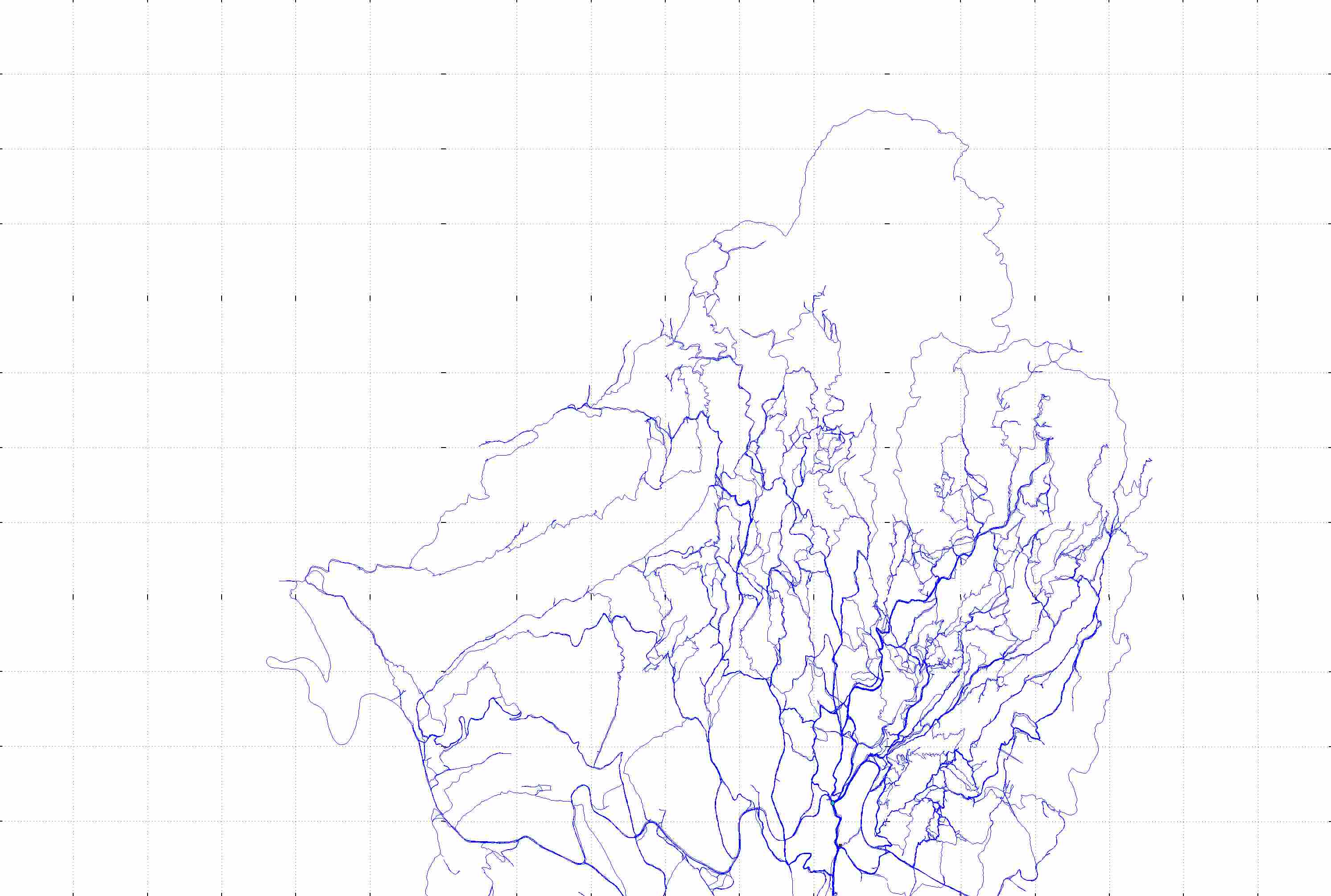
The trail map takes about 2-3 minutes to down load via a 56k modem link. The download will proceed unless you choose to download one of the walks above. On the full trail map there is no attempt to distinguish between grades of trails - all are marked by a single thin line. However, because of locational errors, the trails used most often look thicker because successive mapping do not exactly suprimpose. These 'thick-looking' trails are generally the main, well marked trails. This is a first presentation of the 'raw' positional data collected during walks in the San Felipe valley over the last 18 months since the US Department of Defense opened the Global Positioning System (GPS) to the general public. Prior to 1 May 2000, the D.O.D. had insisted that knowledge of ones position on earth was contrary to interests of national security, and had arranged for the GPS to give falsified positional information to anyone (i.e. except the the military) who had not been granted Selecive Access. Prior to collecting the data, I had explored the trails for about 5 years. The data were collected as latitude/longitude positions using Clarke's 1866 reference ellipsoid model and the North American datum of 1927 as employed in the production of the first edition of the local 1:50,000 topographical sheets by INEGI. The latitude/longitude postions were converted to the grid co-ordinates corrsponding to this system. Note that the second edition of the local topo sheets by INEGI also show the grid system based on the WGS-84 ellipsoid; if you use this trail data in conjunction with the second edition sheet, be sure to refer to the older grid sytem, the difference can be as much as 100 m. on the ground.
[The deviation of the earth's shape from a true sphere is approximated by assuming the shape is ellipsoidal. Clarke's 1866 ellipsoid has generally been replaced by the 1984 WGS-84 ellipsoid, but the first edition (1987) of the INEGI 1:50,000 sheets used the Clarke 1866 ellipsoid. The recent second edition (1999) of the sheets used the WGS-84 ellipsoid, but also includes the grid calculated from the Clarke 1866 ellipsoid as well. The North American datum of 1927 is used to define the origin of the grid system. When positions on earth are transformed to a flat sheet, using the transverse mercator projection, the choice of reference ellipsoid causes an apparent shift in the grid lines relative to the latitude/longitude lines of about 100 m. in the Oaxaca area.]
With the removal of Selective Access on 1 May 2000, it became possible to map trails to an accuracy of at 10 meters (3 meters in good satellite visibility conditions) using a simple hand held commercial GPS unit. (I use a Garmin 12 XL, but don't construe this as a recommendation, I never tried any other GPS unit.) I use an external antenna to improve reception in heavily wooded areas, and take positional readings every 10 seconds. The use of an external antenna on my shoulder allows me to keep the GPS unit in a pouch on my belt and forget all about the mapping activity while I am walking.
The data are uploaded from the GPS unit to a Mac using GPSy software and transferred to a Sun Sparc station for plotting on screeen using the Gnuplot (freeware). Screen plots are then captured using xwd (X Window Dump), converted to ppm format, concatenated and converted to GIF format using the Portable Bitmap Package (freeware). Final editing was performed using the Image section of Star Office, and the final maps saved in JPEG format with 15% quality resolution. The current full trail map is about 0.25 MBytes.
Many of the trails have been walked over many times, and the reprodcibility of the data appears in the thicker lines (up to about 1 mm. on the screen) The scale of the map is aboout 1:10,000 so that 1 mm. on the screen corresponds to about 10 m. on the ground. the scale on the screen of course depends on the dot pitch of the screen: on the 0.29 mm. pitch screen I use, the scale is actually 1: 9,450. On modern screens, the dot pitch is unlikely to vary outside the range 0.25 - 0.35 mm. so the scale you see might vary between about 1:11,000 and 1:8,000. The dotted grid lines are spaced 500 m. apart in all representations.
The first screen you seen will have no trails marked on it - you will have to scroll right and down to get to the area mapped.
Two very obvious deficiencies in this first presentation of trail data are the lack of any altitude measurements (or contours), and the shortage of any identification of places. The only places marked on the map are the bus terminus at San Felipe del Agua - the end of the road (marked by a black square), and the entrance to the Parque Comunal and the Benito Juarez National Park, the small Police station at the entrance gate (marked by a small blue circle.) To find these quickly, scroll to the bottom edge of the map, then about 2/3 of the way across to the right. The place name problem is a characteristic of the area - named points on the 1:50,000 topographical map of the area are restricted to the name of the principal peak - La Pena de San Felipe (just off the trail map to the north. Two other points are known locally as La Cascada (a big waterfall at the head of the lower valley, a popular walk), and La Sacrificia (a prominent look out point over the pueblo), but these are not named on the topo map, nor are they marked on this trail map at present; and that's about all.
I have tried superimposing the trail data on top of a digitized copy of the local 1:50,000 topographical maps (the first edition) which was produced from arial photography at a scale of 1:90,000. The results were not encouraging - the main river of the San Felipe Valley was displaced by 200 m. from the GPS data, so that the main trail up the valley on the left (west) side of the river appeared to be high up on the hillside to the right (east) side of the river. The recent second edition of the topo maps has been produced from arial photography at 1:75,00, and will (presumably) show better agreement with the GPS data.
The software version in my Garmin 12 XL does not automatically record heights (these were very unreliable during the time of Selective Access.) With the removal of Selective Access, heights are generally reliable to about 30 ft., and spot heights need to be included in the trail map.
WARNING: I personally make no claims for accuracy of this map, which is offered on a best efforts basis. Responsibility for accuracy is shared between the U.S. Department of Defense which administers the GPS satelites and Garmin who produce the receiver unit. The claims of both these organisations suggest that accuracy should be within 10 m. given adequate satellite visibility. Satellite visibility is generally extremely good in the area (normally 8-10 satellites) with the exception of a very few locations in very steep sided valleys such as La Cascada (where satellite visibility can drop to 3-4).